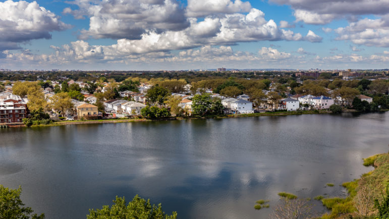
Adi Talwar
Neighborhoods like Canarsie are where working-class families could get severely squeezed amid rising flood risks, soaring insurance rates and the difficulty of elevating their homes.
City Limits is participating along with hundreds of news organizations around the world on climate-related stories in the week leading up to the United Nations Climate Summit. More at #CoveringClimateNow.
If housing affordability and climate change resiliency are two of the most pressing challenges facing New York City, the flood zone marks their contested intersection. As heavy rainfall inundates subway stations, sewer mains, and even Staten Island buses, residents of the city’s low-lying, water-fronted, neighborhoods brace, unsure if an extreme storm will render their homes temporarily — or permanently — uninhabitable.
Yet for the largely middle- and working-class homeowners in these neighborhoods, another rising tide threatens their ability to stay put, even on dry and sunny days: flood insurance.
Owners on the city’s coastline and their advocates are bracing for impact as two more major anticipated changes to federal flood insurance policy promise to fundamentally alter the landscape of affordable housing in New York City.
Growing risks, and costs
Homeowners in “high risk flood zones,” as charted by the Federal Emergency Management Administration, are required by law to purchase flood insurance if they hold federally-backed mortgages. As flood damage isn’t covered by regular homeowner’s insurance, the majority of these homeowners purchase insurance from private companies at rates set under FEMA’s National Flood Insurance Program.
Owners outside the high-risk zones who have received public disaster assistance from FEMA or participated in local programs like Build It Back are also required to insure their homes.
When Superstorm Sandy far overran the bounds of the previously mapped flood risk, flood insurance went from a tithe on the luxuries of beachfront living to a financial pressure on thousands of homeowners in Staten Island, Brooklyn, and Queens. Recently, that financial pressure has been intensifying.
The majority of homes in New York’s flood zones were built before 1983, when the adoption of risk maps began to dictate construction standards in the flood plain. Historically, such homes have been eligible for subsidized insurance rates.
Nevertheless, flood insurance premiums can run thousands of dollars per year — a significant drain for the working class homeowners of New York City’s flood zones. In 2017, a RAND Corporation study of the financial burden of flood insurance in New York City found that the average annual premium on a house in a high risk flood zone was $3,000, with some homeowners paying almost $10,000 per year. (Nationally, that year, the average flood insurance premium was $700.)
The study estimated that 25 percent of all New York City homeowners in the high risk zone, including 60 percent of very low-income and 40 percent of low-income homeowners, were already struggling with a prohibitively expensive combination of flood insurance premiums, property taxes, and mortgage payments.
To make matters worse, in 2012, Congress passed legislation aimed at saving FEMA’s insurance program from insolvency, and those subsidies gradually began to wane, causing flood insurance premiums to rise. Though those increases were later limited by subsequent legislation, premiums may still increase up to 18 percent per year; nationally in 2018, premiums went up by 8 percent overall.
Much maligned maps remain a mystery
Even bigger changes now loom.
Though FEMA issued “advisory” flood zone hazard maps as recently as 2017, it has not updated its official maps — which dictate construction standards and insurance obligations — since 1983. Lack of insurance following from the outdated maps contributed to the devastation of Hurricane Sandy, as homeowners without insurance struggled to navigate the complex bureaucracy of federal disaster aid and repair their homes.
The revision has been at the top of the city’s priority list ever since, not least because homeowners in high-risk flood zones can secure discounted insurance rates by elevating their homes — an incentive likely to reduce the damage wrought by future floods.
But altered maps will inevitably mean more homes in the floodplain and more homeowners obligated to buy flood insurance, making the last refuge of low-income homeownership steadily less affordable.
When FEMA issued a preliminary revision to the New York City flood hazard maps in 2015, the city government appealed it forcefully, arguing that the agency had overestimated the extent of the floodplain and the height of future floods, saddling too many homeowners with too high a level of risk. In 2016, FEMA accepted the appeal and went back to the drawing board.
Since then, according to Caroline Nagy, director of research at the Center for New York City Neighborhoods (CNYCN), there’s been no further insight into what the updated maps portend. Housing advocates predict that new maps will be released sometime in 2022, likely without forewarning. Until then, Nagy says, “we’ve been working blind.”
Rating system is another variable
A change that more recently appeared on the horizon, and is even less well understood, is a new flood risk rating system.
FEMA’s method of measuring flood risk determines flood insurance premiums for those homeowners who have to buy it; this method, like the hazard maps, had not kept pace with the changing technology and climate.
Historically, flood insurance obligation has been a relatively simple calculation: An owner is either in a high-risk zone, and has to buy insurance, or isn’t, and doesn’t; rates are determined by the difference between the elevation of the home and the “Base Flood Elevation,” or the anticipated water-level of future floods; subsidies offset the expense somewhat.
In March, FEMA announced a “Risk Rating 2.0” initiative, to take effect in October 2020 — but the agency described the new policy only in brief, vague terms. The adjusted rating system strives to “close the insurance gap,” and will incorporate granular, lot-by-lot details, which could potentially include the cost of reconstructing the home; the distance from a shoreline or riverbank; differing impacts of different kinds of floods; or the structure’s history of flooding.
Like the flood hazard maps to come, Risk Rating 2.0 is a black box. All 5 million current policyholders nation-wide will see their rates change under the Risk Rating 2.0 system — but until FEMA releases a more detailed policy description, the precise shape and direction of that change remains a mystery.
It’s no surprise that changing the system has been contentious and slow going. Rising insurance rates could drastically impact affordability for individual owners, and the housing market as a whole, as insurance-obligated houses become more expensive to own and more difficult to sell.
The 2017 Rand Corporation study projected that the elimination of “grandfathering” — which allows currently uninsured homeowners outside the flood zone to buy insurance at a rate reflecting their current, lower level of measured risk before the adoption of new hazard maps — could nearly double the median flood insurance premium, and depress property values by tens of thousands or even hundreds of thousands of dollars.
Risk, rates and resiliency
It’s not clear at this point whether Risk Rating 2.0 will preserve the grandfathering policy, but Noreen Clancy, a RAND policy analyst and one of the 2017 report’s co-authors, says that the structure- and risk-based rating method reflected in the March announcement suggests hazard map-based subsidies like grandfathering may soon be on the chopping block.
“On a theoretical level, it’s a good idea to move people toward more risk-based rates,” Clancy says. “Subsidized prices may be giving people a distorted sense of their risk.”
Eliminating subsidies could also help tame the NFIP debt, which peaked at $30.4 billion in 2017. Citing its “unsustainable” finances, Congress has granted the program only months-long, temporary reauthorizations since that year, the most recent of which is set to expire on September 30
But from homeowners’ perspective, a more precise and subtle picture of the hazards of the flood zone may not be welcome, if it increases to the cost of staying in their homes.
The March announcement drew outcry from homeowners on Long Island, who anticipate higher premiums as a result of the high regional cost of construction — one factor that could be included in the new calculus. Whether their fear will come to pass is still unknown.
Based on the limited information currently available, Nagy says, New York City homeowners in different neighborhoods could feel the effects to different extents, but rates will likely go up for many. And any increase, even if capped at 9 percent per year — the figure proposed in a bipartisan measure intended to safeguard against rate spikes as a result of the “untested and unknown methodology” — could be the final straw for homeowners already feeling squeezed.
Foreclosure before the flood?
There’s reason to believe that the squeeze is very much felt in many of New York’s flooding-vulnerable neighborhoods, where foreclosure rates spiked precipitously in 2017 and have continued to rise. Neighborhoods like Bergen Beach and New Dorp, which were among the hardest hit by Hurricane Sandy, have seen foreclosure rates increase two- or three-fold in the last three years — a much steeper increase than in the city as a whole. In the most recent quarter, while the number of foreclosures across the city as a whole actually decreased, in neighborhoods like Canarsie, Bergen Beach, and Mill Basin, the number of foreclosures, and especially pre-foreclosure filings, went up.
Foreclosure prevention attorneys and homeowner advocates in Brooklyn and Staten Island caution that gradually increasing flood insurance rates aren’t likely to be driving the trend behind foreclosures at this point. Canarsie, for instance, has more mortgage-bearing, low-income homeowners than the city on average, and was an epicenter during the 2008 foreclosure crisis. “The reasons our clients are in foreclosure are the same as ever: loss of income, medical crisis, or change in family composition,” says Angella Davidson, director of the Foreclosure Prevention Program at Neighborhood Housing Services of Brooklyn, which serves homeowners threatened by foreclosure in South Brooklyn neighborhoods including Canarsie.
But financial difficulties have a way of compounding one another, and current pre-foreclosure filing numbers paint a picture of low-lying, flood-prone neighborhoods on the brink of a crisis. Increasing flood insurance premiums could tip the scales.
Rose Marie Cantanno, supervising attorney for the foreclosure prevention project at New York Legal Assistance Group, says some clients, especially elderly homeowners, are already finding themselves financially drained by the combination of flood insurance premiums and property taxes. (New York’s flood zone neighborhoods have a greater proportion of residents over 70 than the city as a whole, according to a study of flood insurance and affordability published by CNYCN in 2017.) For owners on a fixed income, increases in perpetuity will swiftly become untenable. “It’s a problem now; it’s about to be a much bigger problem,” Cantanno says.
Yet there is room for optimism, according to Nagy. Subsidies to offset the cost for some homeowners will remain in place, and caps on the annual rate of increase are likely to be preserved when the new rating system comes into effect. And more detailed information about flood risk poses an opportunity of a sort, to educate homeowners and push for investment in mitigative and adaptive measures.
Under the current system, elevating a house yields credit toward a subsidized premium; Risk Rating 2.0 will probably include credits for a wider range of activities, including moving expensive appliances and building system elements to higher floors. For owners of prototypical New York row houses, which prove more or less impossible to elevate, this policy change could mean a viable opportunity to outfit their homes for greater resiliency, and to access lower insurance rates in the process.
Nagy also suggested that widening the flood plain could spur a broader conversation. “The conversation about flooding tends to be binary, but there’s a whole spectrum of risk,” Nagy says; different mitigation and adaptation policies might be appropriate for homeowners facing different levels of threat. A more subtle rating system could lend credence to policies such as means-tested subsidies and buy-outs for “managed retreat,” which were more popular than available in the wake of Superstorm Sandy, Nagy says.
No matter what, the arrival of new flood hazard maps on the heels of a new risk rating system will mean that homeowners in these neighborhoods will have to undertake several complicated, financially significant decisions in a very short period of time. But until then, they wait.


3 thoughts on “NYC Homeowners Face Huge Unknowns as Flood Insurance Changes Loom”
There are options other than FEMA based policies not subject to those increases.
http://www.FastAndEasyFloodInsurance.com is one that offers private flood insurance.
Pingback: NYC Homeowners Face Huge Unknowns as Flood Insurance Changes Loom - New York Legal Assistance
What about Manhattan neighborhoods? I understand and respect your advocacy for low to moderate income neighborhoods but other residents deserve analysis too.